El Nino weather phenomenon and the ski touring winter in Switzerland
What weather phenomenon could contribute to this? El Niño is in full swing and here are some aspects of it!
Learn more about the weather and ski touring with us!

This winter is off to a great start. Even now, at the beginning of November, there has been a considerable amount of fresh snow in the mountains. In the lowlands and at low altitudes, there hasn't been much to see yet, but in Valais, Engadin and generally on the main Alpine ridge above around 2000 metres above sea level, with a focus on Engadin and Lower Valais, it has snowed well. "The leader in snow measurements is the automatic IMIS station L'Ecreuleuse (2252 m) with a 4-day snowfall total of a whopping 172 cm. The snow depth reached a new daily record of 124 cm. Previously, the maximum amount of snow on a 5th November was 83 cm, with an average of 21 cm. This in a measurement series that now spans 26 years." SLF Avablog, 6 Nov. Which weather phenomenon could contribute to this? El Niño is in full swing and here are some aspects of it!

The weather phenomenon El Niño and its sister La Niña occur between South America and Australia. Although they are relatively far away from Europe, the Alps and Switzerland, they influence our climate. El Niño and La Niña are weather patterns in the southern Pacific Ocean that form near the Tropic of Cancer. Local fishermen call the phenomenon "The Christ Child" because it is particularly strong at Christmas and has no fish left due to the changing ocean currents (El Niño as "Christ Child Boy" and La Niña as "Christ Child Girl"). Normally, La Niña is predominant, with air circulating from South America to Australia/Indonesia. Every few years, this condition changes and an El Niño occurs, which is currently prevailing.

During an El Niño, the difference in air pressure between South America and Australia decreases. The trade winds, which normally blow from east to west, become weaker, come to a standstill or even reverse in extreme cases. This results in droughts in Australia and Indonesia and heavy rainfall in South America. In addition, La Niña contributes to a cooler global temperature, while El Niño intensifies the warming. The effects of this mainly affect the Pacific and Africa and also influence the weather in Europe. The effect is not clear-cut and many other factors play a role. El Niño increases the likelihood of a wet start to the winter (Nov-Jan) due to westerly wind-driven weather and a dry and cold rest of the winter (Feb-Apr). Perfect so to experience ski touring with us!

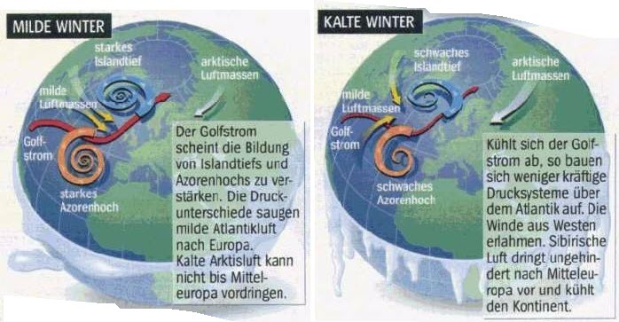
Basically, the weather in Europe is dominated by a westerly wind or a north-easterly, Siberian, cold and dry current. The westerly wind brings moisture to the Alps and corresponds to the three snowfall periods of the last 10 days. The driving force behind this is the interplay between the Icelandic low, the Azores high and the Gulf Stream. If the pressure difference (North Atlantic Oscillation, NAO) between Iceland and the Azores is large, a westerly wind prevails with mild and wet winters. If the difference is small, cold, dry air from Siberia reaches Switzerland (bisection). Much more important for our winter is the presence of the Gulf Stream and thus the westerly winds. A La Niña year increases the probability that winter will begin with a westerly wind and end with a westerly wind. Find out more about the weather and its behaviour on ski tours on our ski touring courses!

The weather remains exciting and we are ready for whatever may come. Because Switzerland, with its unique topography, the north and south sides of the Alps and the inner-Alpine regions, leaves plenty of room for manoeuvre. So today Florian is climbing in sunny and warm Ticino and Jonas is opening the ski season in wintry Valais.
Come along and experience mountain adventures together with motivated Swiss mountain guides and learn more about the weather and the mountains!